Guyane-SIG
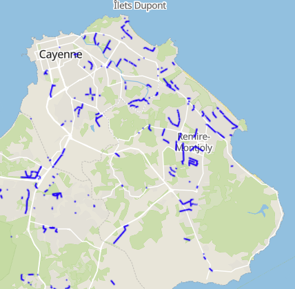
Canaux de largeur entre 2 et 5m - CACL (2025)
Canaux de largeur entre 2 et 5 mètres présents sur le territoire de la Communauté d’Agglomération du Centre Littoral (CACL).
Simple
- Date (Revision)
- 2025-11-28
- Identifier
- 373a8d05-a4f4-4f9a-8c3a-7d98ace5c767
- GEMET - INSPIRE themes, version 1.0
-
- Geographical extent of data sets
- Theme
-
- Voirie et réseaux divers
- eaux pluviales
- cacl
- Access constraints
- otherRestrictions Other restrictions
- Spatial representation type
- vector Vector
- Metadata language
- freFrançais
- Topic category
-
- energies-et-reseaux
- OnLine resource
-
canaux-de-largeur-entre-2-et-5m-cacl-2025
(
OGC:WMS
)
None
- OnLine resource
-
canaux-de-largeur-entre-2-et-5m-cacl-2025
(
OGC:WFS
)
None
- Hierarchy level
- dataset Dataset
- Statement
- Tracé réalisé d’après la BD cours d’eau DGTM, la topographie LIDAR 2015 éventuellement complété par des données terrains. Les intitulés des champs ont été harmonisés et l’encodage des attributs a été vérifié par Guyane-SIG afin d’assurer la bonne lisibilité de la donnée.
- File identifier
- 373a8d05-a4f4-4f9a-8c3a-7d98ace5c767 XML
- Metadata language
- freFrançais
- Hierarchy level
- dataset Dataset
- Date stamp
- 2025-11-28
- Metadata standard name
- INSPIRE Metadata Implementing Rules
- Metadata standard version
- Technical Guidelines based on EN ISO 19115 and EN ISO 19119 (Version 1.2)