 Guyane-SIG
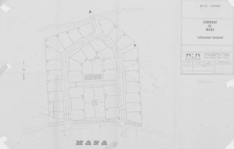
Plan d'un lotissement communal de Mana (1984)
Carte scannée du plan d'un lotissement communal de la commune de Mana.
Simple
- Date (Publication)
- 1984-10-01T00:00:00
- Status
- Completed
Resource provider
Mairie de Mana
-
Service de l’Urbanisme
Place Yves Patient
,
MANA
,
97360
,
Guyane française
Author
AUDeG - Agence d'Urbanisme et de Développement de la Guyane
-
(
)
1 impasse Touloulous
,
CAYENNE
,
97300
,
Guyane Française
Distributor
CTG - Collectivité Territoriale de Guyane
-
Service de l’Information Géographique
4179 route de Montabo - Carrefour de Suzini
,
CAYENNE
,
97300
,
Guyane Française
- Maintenance and update frequency
- Unknown
- Keywords
-
- mana
- guyane
- 1984
- Region
-
- French Guiana
- Other constraints
- Accord nécessaire du fournisseur de cette donnée en préalable au téléchargement
- Spatial representation type
- Grid
- Denominator
- 500
- Metadata language
- Français
- Character set
- UTF8
- Topic category
-
N
S
E
W
))
Distributor
Distributor
CTG - Collectivité Territoriale de Guyane
-
Service de l’Information Géographique
4179 route de Montabo - Carrefour de Suzini
,
CAYENNE
,
97300
,
Guyane Française
- Name
- JPG
- OnLine resource
- LOT_MANA_1984-10_LOTISSEMENT_COMMUNAL.jpg ( WWW:DOWNLOAD-1.0-http--download )
- Hierarchy level
- Dataset
- File identifier
- b83b83e5-809a-430e-a598-f45bce4dec29 XML
- Metadata language
- Français
- Character set
- UTF8
- Hierarchy level
- Dataset
- Date stamp
- 2014-09-25T21:15:35
- Metadata standard name
- ISO 19115:2003/19139
- Metadata standard version
- 1.0
Point of contact
CTG - Collectivité Territoriale de Guyane
-
Service de l’Information Géographique
4179 route de Montabo - Carrefour de Suzini
,
CAYENNE
,
97300
,
Guyane Française
Overviews
thumbnail
large_thumbnail
Spatial extent
N
S
E
W
Provided by

Associated resources
Not available