Guyane-SIG
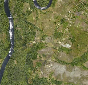
Orthophotographie aérienne de Sinnamary, secteur Pointe Combi (2017)
Orthophotographie aérienne de la commune Sinnamary, secteur Pointe Combi.
Simple
- Date (Creation)
- 2017-12-29
- Identifier
- c3841f13-1798-426a-8f0b-cb497af11754
- GEMET - INSPIRE themes, version 1.0
-
- Étendue géographique des données
- Theme
-
- Sinnamary
- 2017
- Use limitation
- Données ouvertes
- Access constraints
- otherRestrictions Other restrictions
- Other constraints
- Données ouvertes
- Spatial representation type
- vector Vector
- Metadata language
- freFrançais
- Topic category
-
- limites-administratives-et-referentiels
- OnLine resource
-
SINNAMARY_POINTE_COMBI_ORTHO_2017
(
OGC:WMS
)
None
- OnLine resource
-
SINNAMARY_POINTE_COMBI_ORTHO_2017
(
OGC:WCS
)
None
- Hierarchy level
- dataset Dataset
- File identifier
- c3841f13-1798-426a-8f0b-cb497af11754 XML
- Metadata language
- freFrançais
- Hierarchy level
- dataset Dataset
- Date stamp
- 2017-12-29
- Metadata standard name
- INSPIRE Metadata Implementing Rules
- Metadata standard version
- Technical Guidelines based on EN ISO 19115 and EN ISO 19119 (Version 1.2)