 Guyane-SIG
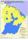
SDOM carte n°1, Répartition du territoire entre activité minière autorisée et activité minière interdite
Le schéma départemental d’orientation minière (SDOM) de la Guyane a pour vocation de définir les conditions générales applicables à la recherche minière ainsi que les modalités de l’implantation et de l’exploitation des sites miniers. Il définit un zonage des secteurs ouverts et interdits à l’activité minière et fixe au besoin des contraintes particulières sur certaines zones.
Simple
Identification info
- Date (Publication)
- 2011-12-30T00:00:00
Point of contact
DEAL Guyane
-
Unité mines et carrières
(
Service Risques Energie Mines et Déchets
)
0594297530
- Régions de France
-
- GUYANE
- INSPIRE Service taxonomy
-
- infoMapAccessService
- INSPIRE inspires
-
- Zones de gestion, de restriction ou de réglementation et unités de déclaration
- Domaines
-
- MINE_CARRIERE_GRANULATS
- GRAND_PUBLIC
- Domaines
-
- GRAND_PUBLIC
- MINE_CARRIERE_GRANULATS
- DGTM
- Access constraints
- Other restrictions
- Use constraints
- Copyright
- Other constraints
- Cette carte ne constitue qu'un caractère indicatif et provisoire compte-tenu de l'échelle et de l'évolution des données qui y sont figurées.
- Classification
- Unclassified
- Service Type
- invoke
- Description
- Guyane
N
S
E
W
))
- Coupling Type
- Tight
Contains Operations
- Operation Name
- Accès à la carte
- Distributed Computing Platforms
- Web services
- Connect Point
- https://catalogue.geoguyane.fr/geosource/consultation?id=91947 ( WWW:LINK-1.0-http--link )
- Reference system identifier
- EPSG / RGFG95 / UTM zone 22N (EPSG:2972) / 7.9
- OnLine resource
-
Accès à la carte
(
WWW:LINK-1.0-http--link
)
Accès à la carte
- Hierarchy level
- Service
- Statement
-
Le SDOM a été approuvé par le décret no 2011-2105 du 30 décembre 2011.
Carte réalisée au format A4 (échelle 1/1900000) et intégrée au schéma départemental d’orientation minière.
- File identifier
- c8a90f86-14cf-4813-aad0-6837f9deb46f XML
- Metadata language
- fre
- Character set
- UTF8
- Hierarchy level
- Service
- Hierarchy level name
- service
- Date stamp
- 2020-07-23T15:06:27
- Metadata standard name
- ISO 19115:2003/19139
- Metadata standard version
- 1.0
Point of contact
DEAL Guyane
-
Sébastien Linarès
(
Service Planification Connaissance et Evaluation
)
6 rue Carlos Fineley, pointe Buzaré, BP 6003
,
Cayenne
,
97306
,
0594298025
Overviews
large_thumbnail
Spatial extent
N
S
E
W
Provided by

Associated resources
Not available