 Guyane-SIG
2013
Type of resources
Available actions
Topics
Keywords
Contact for the resource
Provided by
Years
Formats
Representation types
Update frequencies
status
Service types
Scale
Resolution
-

The image covers the area between Kourou and Sinnamary near the guyanese spatial center.
-

The image covers the experimental station Paracou in French Guiana.
-

The image covers the experimental station Paracou in French Guiana.
-

The image covers the experimental station Paracou in French Guiana.
-

Subset of the Pléiades image that covers the experimental station Paracou in French Guiana.
-

Mosaic of 569 aerial photographs. The image covers the area around Paracou in French Guiana.
-

The image covers the experimental station Paracou in French Guiana.
-
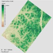
The aerial laser scanning (ALS) dataset acquired on 23 September 2013 covers the experimental station Paracou in French Guiana. The coverage includes all Guyafor and Guyaflux plots completely with logged-over, unlogged and swamp forest ("Pinot" or "Açai").
-

The site Limonade is composed of three 3km-transects (20m wide). 3354 trees with dbh>=20cm have been recorded by Office national des forêts (ONF). Fauna inventories have been made by Office national de la chasse et de la faune sauvage (ONCFS) few days after. No under-storey plots on this site. Soils have been described using 16 samples (1.20m depth max.). No laboratory analysis available for soils.
-

The site Crique Armontabo is composed of four 3km-transects (20m wide). 5183 trees with dbh>=20cm have been recorded by Office national des forêts (ONF). Fauna inventories have been made by Office national de la chasse et de la faune sauvage (ONCFS) few days after. No under-storey plants inventory available. Soils have been described using 12 samples (1.20m depth max.). Laboratory analyses are available for one soil-profile.