 Guyane-SIG
2016
Type of resources
Available actions
Topics
Keywords
Contact for the resource
Provided by
Years
Formats
Representation types
Update frequencies
status
Service types
Scale
Resolution
-

Mosaic of color and near infrared aerial photographs. The image covers the area around Paracou in French Guiana.
-
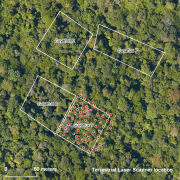
The terrestrial laser scanning (TLS) dataset covers the Guyaflux plot 9 of the experimental station Paracou in French Guiana.
-

The aerial laser scanning (ALS) dataset acquired on 20 October 2015 covers the experimental station Paracou in French Guiana. The coverage includes all Guyafor and Guyaflux plots completely with logged-over, unlogged and swamp forest ("Pinot" or "Açai").
-

The UMR EcoFoG possesses several servers of administration or calculations. All are situated within the building INRA, office 207, of the Agronomic Campus of Kourou, French Guiana. The servers of calculations are: 1. Carapa, Tabebuia and Amandier: servers of calculation under Linux (Ubuntu), each possesses a server RStudio which allows to throw calculations under R from a Web browser (Firefox rather). 2. Wanakouali : His use is reserved for the supercomputing under Windows. His storage capacity is reduced (400 Go) but its hard drives are very fast. Installed softwares : R, Révolution R, RStudio, Tinn-R, OpenBUGS, MATLAB.
-

The terrestrial laser scanning (TLS) dataset covers Guyaflux plots 1 and 9 at the experimental station Paracou in French Guiana.
-
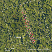
The terrestrial laser scanning (TLS) dataset covers a transect in plot 15 at the experimental station Paracou in French Guiana.
-

High density aerial laser scanning (LIDAR) dataset acquired on 22 October 2015. The dataset covers 27.4 km² including the research station in the Nouragues reserve.
-

Mosaic of color and near infrared aerial photographs. The image covers 27.4 km² including the research station in the Nouragues reserve.
-
This dataset summarizes the facilities that can be used within labex CEBA for the scientific work.
-
Ensemble de produits (Modèles Numériques de Terrain/Surface/Hauteur, Ortho-images) réalisés en 2015 sur les zones anthropisées de la commune de Roura.