 Guyane-SIG
Biota
Type of resources
Available actions
Topics
Keywords
Contact for the resource
Provided by
Years
Formats
Representation types
Update frequencies
status
Scale
Resolution
-
The terrestrial laser scanning (TLS) dataset covers the Guyaflux plot 9 of the experimental station Paracou in French Guiana.
-

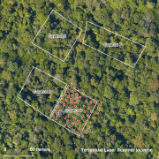
The terrestrial laser scanning (TLS) dataset covers Guyaflux plots 1 and 9 at the experimental station Paracou in French Guiana.
-
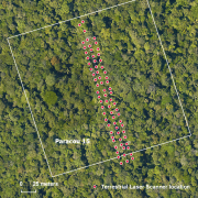
The terrestrial laser scanning (TLS) dataset covers a transect in plot 15 at the experimental station Paracou in French Guiana.
-
The UMR EcoFoG possesses an herbarium reference collection based on samples harvested all along the different forest plots studied by our teams. This collection is maintained by a botanist and stored on the Agronomical Campus of Kourou, INRA building. A Excel database is linked to this collection and the taxa found in it are listed in the Guyafor database. The collection gathers more than 3000 samples representing 74 families, 288 genera and more than 800 taxa.
-

The “Herbier IRD de Guyane” (CAY) was established in 1965 by R.A.A. Oldeman and harbors nearly 200000 specimens, mostly from French Guiana and nearby countries Suriname, Guyana, Brazil (particularly the state of Amapá), and Venezuela (state of Amazonas). The dataset presented here is the fruit of 30-years’ work by CAY’s staff as well as that of numerous other botanists who have helped make CAY a key scientific platform and leading center of botanical research for the Guiana Shield.
-
Geographical distribution of three nuclear clusters (Q1, Q2, Q3) inferred by a Bayesian clustering analysis (STRUCTURE) after evaluating genetic diversity at nine nuSSR over 217 Jacaranda copaia in five regions in the Neotropics (Western Amazonia, Southern Amazonia, Central Amazonia, Guiana Shield, Central America). For more details, see Scotti-Saintagne et al., 2013 Journal of biogeography vol 40 pp 707-719. This work was funded by the EU-funded INCO “SEEDSOURCE” project, by the EU-funded PO-FEDER “ENERGIRAVI” program and the ANR funded Programme “BRIDGE”
-

The site Roche Koutou is composed of four 2 to 3km-transects (20m wide). 4411 trees with dbh>=20cm have been recorded by Office national des forêts (ONF). Fauna inventories have been made by Office national de la chasse et de la faune sauvage (ONCFS) few days after. 756 under-storey plants have been inventoried on 34 plots on this site (IRD). Soils have been described using 16 samples (1.20m depth max.). No laboratory analysis available for soils.
-

The site Haute Matarony is composed of four 3km-transects (20m wide). 5463 trees with dbh>=20cm have been recorded by Office National des Forêts (ONF). Fauna inventories have been made by Office national de la chasse et de la faune sauvage (ONCFS) few days after. There is no inventory of under-storey plants on this site. Soils have been described using 9 samples (1.20m depth max.). Laboratory analyses are available for one soil-profile.
-

This “Inventaire Papetier” was conducted by the CTFT in 1975. The block covers 59 895 ha. 34 016 trees have been inventoried in 244 plots (120 ha) Pre-census DBH is 15 cm on all plot (originally trees with DBH 10-15cm have been measured on one plot out of 10 but not included in the digital version) DBH have been measured by classes : 15-20 cm for the first class and with a range of 10 cm since 20 cm. Plots have been located on GIS in 2008 using original maps and field note-books (indicating slopes, rivers, etc...).
-

The site Yaroupi is composed of four 3km-transects (20m wide). 3965 trees with dbh>=20cm have been recorded by Office national des forêts (ONF). Fauna inventories have been made by Office national de la chasse et de la faune sauvage (ONCFS) few days after. No under-storey plots on this site. Soils have been described using 22 samples (1.20m depth max.). Laboratory analysis are available for one soil-profile.