 Guyane-SIG
Counami
Type of resources
Available actions
Topics
Keywords
Contact for the resource
Provided by
Years
Formats
Representation types
Update frequencies
status
Scale
Resolution
-

The aerial laser scanning (ALS) dataset, acquired in 2004, covers three plots of Counami site in French Guiana. The laser recorded last reflected pulse. Ground points data where not delivered by ALTOA.
-

The image covers the experimental sites Counami, Paracou, Piste Saint Elie, Crique Plomb and Montagne Plomb in French Guiana.
-

The image covers the experimental sites Counami, Paracou, Piste Saint Elii, Crique Passoura, Crique Plomb and Montagne Plomb in French Guiana.
-
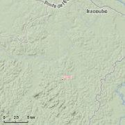
Guyadiv is a network of permanent forest plots installed in French Guiana. The site of Guyadiv in Counami is composed of 19 1200sq.m-plots. A complete inventory has been made on these plots, during 3 inventory sessions in 2000, 2001 and 2002. 1743 trees have been inventoried, with 92,2% to 100% of trees identified to species level. We only have the point coordinates and not the precise demarcation of the sample plots. In order to calculate the bounding box for these plots, we have expanded the point location 500 meters in each direction.
-

Guyadiv is a network of permanent forest plots installed over the years in French Guiana. In these plots, all trees above 10 cm dbh are identified, measured and mapped. Several plots are part of permanent research stations (Paracou, Nouragues, Piste Saint Elie). The diversity of arborescent species flora is studied (floristic list). This flora diversity depends on the forest vegetation (architecture, structure, biomass, dynamic in the long term, dynamic after perturbation and biogeography) which is also studied. The contribution of flora diversity to forest vegetation (carbon cycle issue...) is another topic approach in the studies. Analyses are conducted at different spatial scales (local - intra site, regional, subcontinental via ATDN network) and temporal scale (impact of logging, impact of old settlements : COUAC project). We only have the point coordinates and not the precise demarcation for most of the sample plots. In order to calculate the bounding box for these plots, we have expanded the point location between 100 and 600 meters in each direction. Information specific of each site (Paracou, Montagne Plomb, Crique Plomb, Piste Saint Elie, Counami...) is available. Please refer to the attached metadata sheets. This network relies greatly on the IRD Herbier de Guyane (CAY) and its network of international specialists.