 Guyane-SIG
Paracou
Type of resources
Available actions
Topics
Keywords
Contact for the resource
Provided by
Years
Formats
Representation types
Update frequencies
status
Scale
Resolution
-

Subset of the Pléiades image that covers the experimental station Paracou in French Guiana.
-

Mosaic of color and near infrared aerial photographs. The image covers the area around Paracou in French Guiana.
-

The image covers the experimental station Paracou in French Guiana.
-
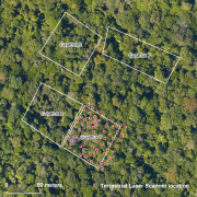
The terrestrial laser scanning (TLS) dataset covers the Guyaflux plot 9 of the experimental station Paracou in French Guiana.
-

The aerial laser scanning (ALS) dataset acquired on 20 October 2015 covers the experimental station Paracou in French Guiana. The coverage includes all Guyafor and Guyaflux plots completely with logged-over, unlogged and swamp forest ("Pinot" or "Açai").
-

The image covers the experimental station Paracou in French Guiana.
-

Subset of the Pléiades image that covers the northern part of the experimental station Paracou in French Guiana.
-

The terrestrial laser scanning (TLS) dataset covers Guyaflux plots 1 and 9 at the experimental station Paracou in French Guiana.
-
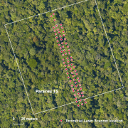
The terrestrial laser scanning (TLS) dataset covers a transect in plot 15 at the experimental station Paracou in French Guiana.
-

Subset of the Pléiades image that covers the experimental station Paracou in French Guiana.