 Guyane-SIG
Sinnamary
Type of resources
Available actions
Topics
Keywords
Contact for the resource
Provided by
Years
Formats
Representation types
Update frequencies
status
Scale
Resolution
-

The image covers the area between Kourou and Sinnamary near the guyanese spatial center.
-

The image covers the area between Kourou and Sinnamary near the guyanese spatial center in French Guiana.
-

The aerial laser scanning (ALS) dataset, acquired in 2004, covers the Sinnamary area in French Guiana.
-

The image covers the area between Kourou and Sinnamary near the guyanese spatial center.
-

Several forest inventories in mangroves were conducted in different places and on different dates. Inventories take place at 6 main locations : Iracoubo, Sinnamary, Macouria, Cayenne, Petit Cayenne and Kaw. 1. at Iracoubo, forest inventories were carried out in 2003 and cover an area of 4800 m², 2. at Sinnamary, forest inventories were conducted in 1997, 2003 and 2004 on 9440 m², 3. at Macouria, 2824 m² were inventoried in 2006, 4. in the south-west of Cayenne, 10800 m² were inventoried in 1993, 5. at Petit-Cayenne, forest inventories were conducted in 2011 on 10000 m², 6. and in the Area of Kaw, three inventories in 2002, 2004 and 2005 cover an area of 34925 m². During the forest inventories, the collected data concern DBH, overall height or 1st branch height, the inter-trees distance in a forest plot, sometimes the surface salinity and state of the tree (living/dead).
-

This dataset gathers the description of primary occurrences of harvestmen (Opiliones) across French Guiana. The database holds 768 georeferenced records. All of the species are identified at least to the family level. Some species are identified to the genus or species level........ (Continue with the description)
-
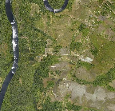
Orthophotographie aérienne de la commune Sinnamary, secteur Pointe Combi.
-
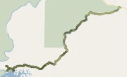
En préalable aux études de réfection de la route d'accès au barrage de Petit-Saut (communes de Kourou et Sinnamary), la Région Guyane a acquis différents produits topographiques ainsi qu'une ortho-image technique couvrant l'intégralité de la route de Petit-Saut. Le produit ortho-image technique est une image rectifiée exploitable pour de la photo-interprétation. Ici, la résolution de l'ortho-image est de 0,1 mètre.
-

En préalable aux études de réfection de la route d'accès au barrage de Petit-Saut (communes de Kourou et Sinnamary), la Région Guyane a acquis différents produits topographiques ainsi qu'une ortho-image technique couvrant l'intégralité de la route de Petit-Saut. L'emprise représente la zone informée (hors NO_DATA) des modèles numériques (MNT, MNS, MNH) ainsi que de l'ortho-image technique.
-
Modèle Numérique de Terrain (MNT) réalisé en 2015 sur la route de Petit-Saut.
