 Guyane-SIG
0.25 m
Type of resources
Available actions
Topics
Keywords
Contact for the resource
Provided by
Years
Formats
Representation types
Update frequencies
status
Scale
Resolution
-

The aerial laser scanning (ALS) dataset, acquired in 2004, covers three plots of Counami site in French Guiana. The laser recorded last reflected pulse. Ground points data where not delivered by ALTOA.
-

The aerial laser scanning (ALS) dataset, acquired in October 2004, covers five plots of Crique Plomb and Montagne Plomb area in French Guiana. In this area. the forest presents contrasting and diversified characteristics : high forest, forest grown on ferricrust, and superficial saprolit with high density of stem per hectare. Ground echoes are available as well as a digital terrain model (DTM), a digital surface model (DSM), and a digital canopy model (DCM) with a 1 meter resolution.
-
Aerial laser scanning (ALS) dataset, Montagne Trinité, French Guiana, acquired on 24 September 2014.

The aerial laser scanning (ALS) dataset acquired on 24 September 2014 covers eastern and western side of Montagne Trinité. Data acquired in the framework of DynForDiv project. Z1 ( East side of the montain); point density: all returns 17.83 last only 10.62 (per meter square) Z2 ( West part of the moutain); point density: all returns 18.97 last only 10.61 (per meter square)
-

The aerial laser scanning (ALS) dataset acquired on 24 September 2014 covers three ares of Montagne Plomb. Z1 (North Eastern part, north of crique Plomb); point density: all returns 19.30 last only 10.62 (per meter square) Z2 (central part, Eastern part of the mountain); point density: all returns 16.80 last only 10.16 (per meter square) Z3 (most western part, western side of the mountain) ; point density: all returns 17.08 last only 10.48 (per square units) Lidar Riegl LMS Q560 onboard a plane operated by Altoa, swath angle +/-20deg
-

The aerial laser scanning (ALS) dataset was acquired on 7 and 8 August 2014 in the framework of DynForDiv project. It covers mount Itoupé (altitude 830m above sea level) in French Guiana (total covered area = 72 km²). Based on sample tiles (45, 70,192, 201, 256), the mean emitted pulse density is ~12/m², and the mean echo density ~ 19/m². Lidar Riegl LMS Q560 aboard a plane operated by Altoa
-

The aerial laser scanning (ALS) dataset, acquired in 2004, covers the Macouria area in French Guiana.
-

The aerial laser scanning (ALS) dataset acquired on 4 August 2014 covers eastern and western side of Bellevue de l'Inini mountain. Data acquired in the framework of DynForDiv project. Western transect point density: all returns 17.05 last only 9.83 (per square units) Eastern transect point density: all returns 16.83 last only 10.28 (per square units) Lidar Riegl LMS Q560 onboard a plane operated by Altoa, swath angle +/-20deg
-

Ce produit est une orthophotographie aérienne numérique couleur de la zone anthropisée d'Apatou (bourg d'Apatou) du 24/09/2012 rectifiée dans la projection adaptée au territoire couvert.
-

Mosaïque de photographies aériennes à très haute résolution spatiale (25 cm) en infrarouge couleurs de la Réserve Naturelle Régionale Trésor.
-
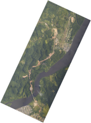
Ce produit est une orthophotographie aérienne numérique couleur de la zone anthropisée de Saint-Georges (bourg de Saint-Georges) du 30/08/2012 rectifiée dans la projection adaptée au territoire couvert.