 Guyane-SIG
Orthoimagery
Type of resources
Available actions
Topics
Keywords
Contact for the resource
Provided by
Years
Formats
Representation types
Update frequencies
status
Resolution
-
Collection of aerial photographs acquired by Institut Géographique National (IGN) in French Guiana. All the aerial photographs are available for free on the IGN geoportail.
-
Subset of the image that covers the area around Régina in French Guiana.
-

One aerial photograph (IGNF_PVA_1-0__1969-09-18__C92PHQ5671_1968_GUY19P_0139) acquired by Institut Géographique National (IGN). The image covers the area around Diane and Malmanoury in French Guiana. We used the image for the project "Feasibility study of the implementation of forest firewalls on the Guyanese Space Center".
-
Subset of the image that covers the area around Saint Georges in French Guiana.
-

Subset of the image that covers the area around Saint Georges in French Guiana.
-

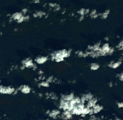
The image covers the experimental station Paracou in French Guiana.
-

Mosaic of 569 aerial photographs. The image covers the area around Paracou in French Guiana.
-

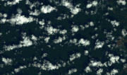
Subset of the image that covers the experimental site Nouragues in French Guiana.
-

Subset of the image that covers the experimental site Nouragues in French Guiana.
-

Subset of the image that covers the experimental site Paracou in French Guiana.