 Guyane-SIG
irregular
Type of resources
Available actions
Topics
Keywords
Contact for the resource
Provided by
Years
Formats
Representation types
Update frequencies
status
Scale
Resolution
-

The site Roche Koutou is composed of four 2 to 3km-transects (20m wide). 4411 trees with dbh>=20cm have been recorded by Office national des forêts (ONF). Fauna inventories have been made by Office national de la chasse et de la faune sauvage (ONCFS) few days after. 756 under-storey plants have been inventoried on 34 plots on this site (IRD). Soils have been described using 16 samples (1.20m depth max.). No laboratory analysis available for soils.
-

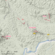
Guyadiv is a network of permanent forest plots installed in French Guiana. The site of Rivière Grand Inini is composed of two 20x500m-plots. A complete inventory has been made in 1990 : 1266 trees with dbh>=10cm have been registrated. 621 species have been identified in the first plot and 639 in the second plot. 99,7% and 99, 4% of the registrated trees have been identified to the species level, respectively on each plot. We only have the point coordinates and not the precise demarcation of the sample plots. In order to calculate the bounding box for these plots, we have expanded the point location 500 meters in each direction.
-

The site Haute Matarony is composed of four 3km-transects (20m wide). 5463 trees with dbh>=20cm have been recorded by Office National des Forêts (ONF). Fauna inventories have been made by Office national de la chasse et de la faune sauvage (ONCFS) few days after. There is no inventory of under-storey plants on this site. Soils have been described using 9 samples (1.20m depth max.). Laboratory analyses are available for one soil-profile.
-

Several forest inventories in mangroves were conducted in different places and on different dates. Inventories take place at 6 main locations : Iracoubo, Sinnamary, Macouria, Cayenne, Petit Cayenne and Kaw. 1. at Iracoubo, forest inventories were carried out in 2003 and cover an area of 4800 m², 2. at Sinnamary, forest inventories were conducted in 1997, 2003 and 2004 on 9440 m², 3. at Macouria, 2824 m² were inventoried in 2006, 4. in the south-west of Cayenne, 10800 m² were inventoried in 1993, 5. at Petit-Cayenne, forest inventories were conducted in 2011 on 10000 m², 6. and in the Area of Kaw, three inventories in 2002, 2004 and 2005 cover an area of 34925 m². During the forest inventories, the collected data concern DBH, overall height or 1st branch height, the inter-trees distance in a forest plot, sometimes the surface salinity and state of the tree (living/dead).
-
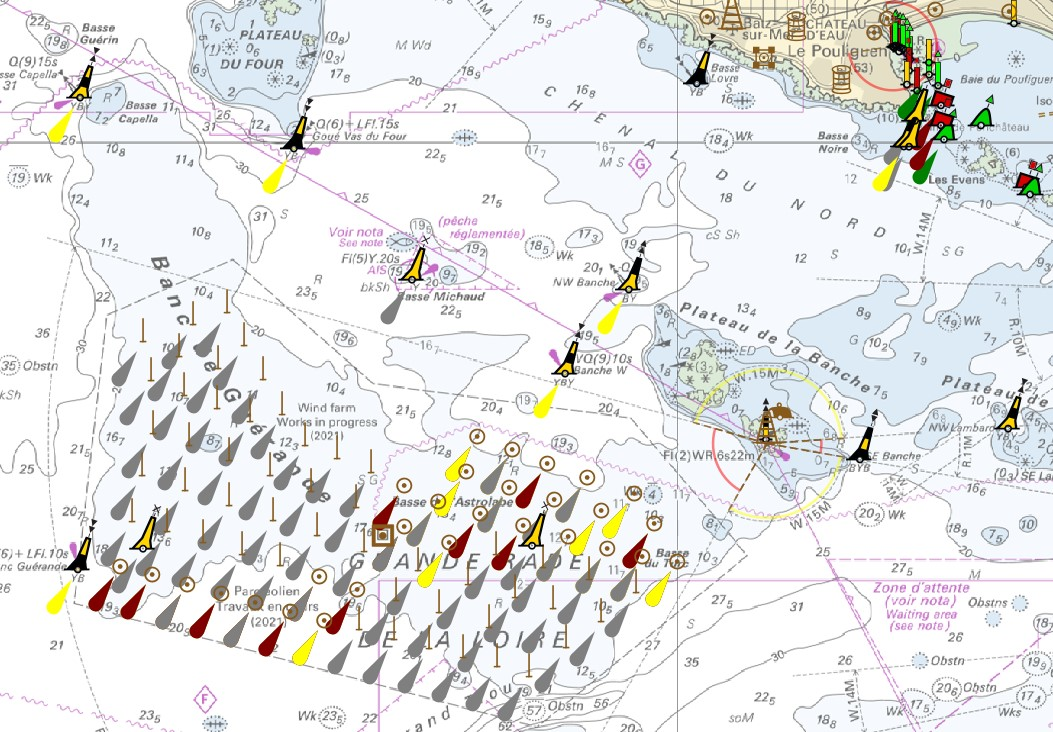
"Aids ton navigation" product contains a description of landmarks, beaconage or buoyage, in the French Exclusive Economic Zone (EEZ). <br /> February 17 2026 version
-

Guyadiv is a network of permanent forest plots installed in French Guiana. The site of Plateau La Douane is composed of one 1ha-plot. A complete inventory of the trees with dbh>=10cm has been made in 2001: 522 trees have been registrated, 518 different species have been identified and 99,2% of the inventoried trees have been identifies to the species level. We only have the point coordinates and not the precise demarcation of the sample plot. In order to calculate the bounding box for the plots, we have expanded the point location 100 meters in each direction.
-

Shom manages a network of permanent digital coastal tide-gauges on French coasts: the RONIM Sea Level Observation Network. Most tide-gauge observatories are partnered with one or more local partners.<br /><br /> Four main types of data are available for download:<br /> - “Raw high frequency" data: raw observations neither validated nor evaluated, obtained directly from the sensor. 1-minute measurement; integration time 15 seconds (on the minute); sampling period: 1 second.<br /><br /> - "Raw non-real time" data: raw observations neither validated nor evaluated, obtained directly from the sensor. 10-minute measurement; integration time 121 seconds (around every 10 minutes); sampling period: 1 second.<br /><br /> - "Validated non-real time" data: observations checked and validated by Shom from the "Raw non-real time" data. 10-minute measurement; integration time 121 seconds (around every 10 minutes); sampling period: 1 second.<br /><br /> - "Validated hourly" data: observations checked and validated by Shom, generated from "Validated non-real time" data. Hourly measurement obtained from the Vondrak filter with triangular weighting. The hourly height cannot be calculated in the event of an observation gap greater than 1.5 hours.
-
Shom is the national referent for the level of the sea in situ on all areas under French jurisdiction. In this capacity, he assures under the acronym REFMAR different coordination functions in the collection and dissemination of public data related to water level observations, in order to promote their use in multiple applications within the framework of international recommendations.
-

The site Itoupé is composed of 6 3km-transects (20m wide). 5516 trees with dbh>=20cm have been recorded by Office national des forêts (ONF). Fauna inventories are available on this site. 834 under-storey plants have been recorded on 35 25m²-plots. Soils have been described using 28 samples (1.20m depth max.). Laboratory analysis are available for two soil profiles.
-
The site Quartzites is composed of two 3km-transects (20m wide). 2638 trees with dbh>=20cm have been recorded by Office national des forêts (ONF). No fauna inventories available. 276 under-storey plants have been recorded on 17 25m²-plots by Institut de recherche pour le développement (IRD). Soils have been described using 13 samples (1.20m depth max.) and two soil pits (1.50m depth). Laboratory analyses are available for one profile and for the two soil pits