 Guyane-SIG
Imagery base maps earth cover
Type of resources
Available actions
Topics
Keywords
Contact for the resource
Provided by
Years
Formats
Representation types
Update frequencies
status
Scale
Resolution
-

The georeferenced digital image solution for the nautical chart is a digital conversion of the corresponding printed nautical chart produced by Shom or its legends, with georeferencing indications and including miscellaneous text.
-
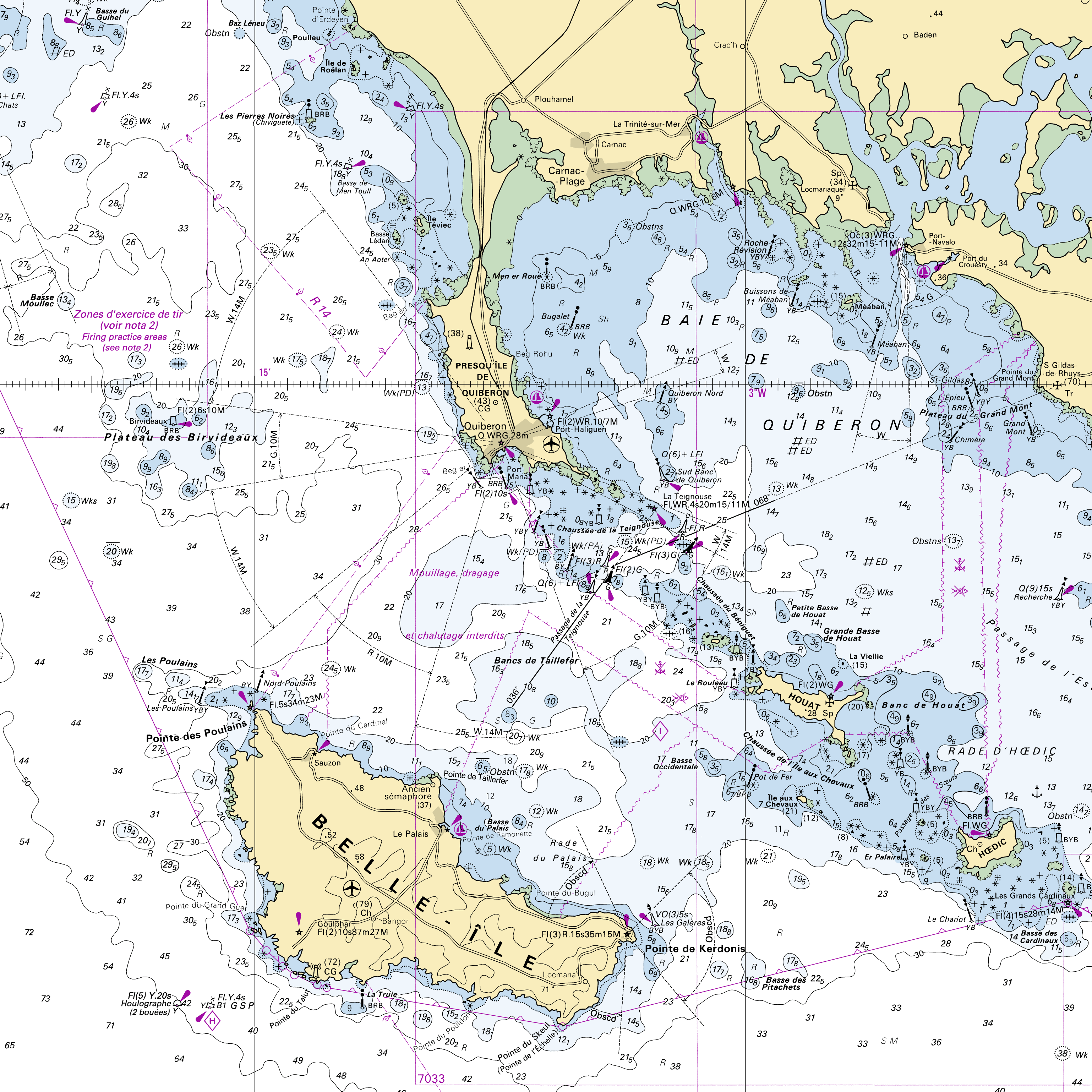
RasterMarine is a series of digital images taken from nautical charts, with no additions, legends or georeferencing information. The RasterMarine range is available at six sets of scales: - RasterMarine10 1:10,000 - RasterMarine25 1:25,000 - RasterMarine50 1:50,000 - RasterMarine100 1:100,000 - RasterMarine350 1:350,000 - RasterMarine1M 1:1,000,000. Unless exceptional circumstances apply, the RasterMarine range is updated on a weekly basis and the modified grid squares are re-published, replacing the previous versions. All corrections, publications, editions and suppressions with an effect on the reference nautical charts are taken into consideration. <br /> 13/05/2026 version <br />
-
Collection of aerial photographs acquired by Institut Géographique National (IGN) in French Guiana. All the aerial photographs are available for free on the IGN geoportail.
-
Subset of the image that covers the area around Régina in French Guiana.
-

Subset of the image that covers the area around Saint Georges in French Guiana.
-

The image covers the experimental station Paracou in French Guiana.
-

The image covers the area between Kourou and Sinnamary near the guyanese spatial center.
-

Subset of the Pléiades image that covers the experimental station Nouragues in French Guiana.
-

One aerial photograph (IGNF_PVA_1-0__1969-09-18__C92PHQ5671_1968_GUY19P_0137) acquired by Institut Géographique National (IGN). The image covers the area around Diane and Malmanoury in French Guiana. We used the image for the project "Feasibility study of the implementation of forest firewalls on the Guyanese Space Center".
-

Subset of the image that covers the experimental site Paracou in French Guiana.