 Guyane-SIG
laser
Type of resources
Available actions
Topics
Keywords
Contact for the resource
Provided by
Years
Formats
Representation types
Update frequencies
status
Resolution
-

The aerial laser scanning (ALS) dataset, acquired on 1 october 2005, covers five plots of the Montagne des Chevaux and the Montagnes des Serpents areas in French Guiana. Each subsite is covered by one data file. The Z2 data area covers a spirotropis forest type area, the Z3 data area covers a riparian vegetation with Avicenia, and the Z4 data area covers a swamp forest.
-

The aerial laser scanning (ALS) dataset, acquired in 2007, covers the research area in the Nouragues reserve. Ground echoes are available as well as a digital terrain model (DTM), a digital surface model (DSM), and a digital canopy model (DCM) with a 1 meter resolution.
-
Aerial laser scanning (ALS) dataset, Montagne Trinité, French Guiana, acquired on 24 September 2014.

The aerial laser scanning (ALS) dataset acquired on 24 September 2014 covers eastern and western side of Montagne Trinité. Data acquired in the framework of DynForDiv project. Z1 ( East side of the montain); point density: all returns 17.83 last only 10.62 (per meter square) Z2 ( West part of the moutain); point density: all returns 18.97 last only 10.61 (per meter square)
-

The aerial laser scanning (ALS) dataset acquired on 24 September 2014 covers three ares of Montagne Plomb. Z1 (North Eastern part, north of crique Plomb); point density: all returns 19.30 last only 10.62 (per meter square) Z2 (central part, Eastern part of the mountain); point density: all returns 16.80 last only 10.16 (per meter square) Z3 (most western part, western side of the mountain) ; point density: all returns 17.08 last only 10.48 (per square units) Lidar Riegl LMS Q560 onboard a plane operated by Altoa, swath angle +/-20deg
-

The aerial laser scanning (ALS) dataset, acquired in 2004, covers three plots of Counami site in French Guiana. The laser recorded last reflected pulse. Ground points data where not delivered by ALTOA.
-
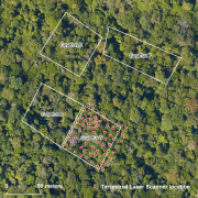
The terrestrial laser scanning (TLS) dataset covers the Guyaflux plot 9 of the experimental station Paracou in French Guiana.
-

The aerial laser scanning (ALS) dataset acquired on 26th September 2011 covers part of the Paracou experimental station in French Guiana. Plots entirely covered include Paracou 4, 5, 7, 8, 9, 10, 11, 12, and 14. Plots 3, 6, 13, and 15 are partially covered by the data. The area includes both natural unlogged forest and logged over forest.
-
The airborne data comprises laser elevation data acquired during an airborne geophysical survey over French Guiana in 1996. The study area, located along the coast in the south of Cayenne in French Guiana, measures 45 km x 55 km. The area is characterized by virgin forest and savannah. Most of the area is flat or slightly undulating, with elevation ranging from 0 to about 400 m above sea level. (e.g. Kaw mountain).
-

The aerial laser scanning (ALS) dataset acquired on 4 August 2014 covers eastern and western side of Bellevue de l'Inini mountain. Data acquired in the framework of DynForDiv project. Western transect point density: all returns 17.05 last only 9.83 (per square units) Eastern transect point density: all returns 16.83 last only 10.28 (per square units) Lidar Riegl LMS Q560 onboard a plane operated by Altoa, swath angle +/-20deg
-

The aerial laser scanning (ALS) dataset, acquired in October 2004, covers five plots of Crique Plomb and Montagne Plomb area in French Guiana. In this area. the forest presents contrasting and diversified characteristics : high forest, forest grown on ferricrust, and superficial saprolit with high density of stem per hectare. Ground echoes are available as well as a digital terrain model (DTM), a digital surface model (DSM), and a digital canopy model (DCM) with a 1 meter resolution.