 Guyane-SIG
France
Type of resources
Available actions
Topics
Keywords
Contact for the resource
Provided by
Years
Formats
Representation types
Update frequencies
status
Service types
Scale
Resolution
-

This landscape dataset was built using Shuttle Radar Topography Mission (SRTM) data with full resolution (1 arc sec ~ 30m). This map aims at evaluating the geodiversity of natural areas. Twelve landscape types into 5 main categories have been identied with respect to Migon's typology (2006): the coastal plains landscapes (AA. AB. AC); the typical multi-convex landscapes (B. I. J); the multi-concave and joint-valley landscapes (C.D); the more or less dissected plateau (E.F.G) and the all-slopes topography (H). The map was produced at the request of the French Guianan public forest manager of the Office National des Forêts (ONF).
-
Collection of aerial photographs acquired by Institut Géographique National (IGN) in French Guiana. All the aerial photographs are available for free on the IGN geoportail.
-

The aerial laser scanning (ALS) dataset, acquired on 1 october 2005, covers five plots of the Montagne des Chevaux and the Montagnes des Serpents areas in French Guiana. Each subsite is covered by one data file. The Z2 data area covers a spirotropis forest type area, the Z3 data area covers a riparian vegetation with Avicenia, and the Z4 data area covers a swamp forest.
-

The aerial laser scanning (ALS) dataset, acquired in 2007, covers the research area in the Nouragues reserve. Ground echoes are available as well as a digital terrain model (DTM), a digital surface model (DSM), and a digital canopy model (DCM) with a 1 meter resolution.
-
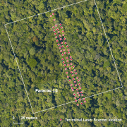
Aerial laser scanning (ALS) dataset, Montagne Trinité, French Guiana, acquired on 24 September 2014.

The aerial laser scanning (ALS) dataset acquired on 24 September 2014 covers eastern and western side of Montagne Trinité. Data acquired in the framework of DynForDiv project. Z1 ( East side of the montain); point density: all returns 17.83 last only 10.62 (per meter square) Z2 ( West part of the moutain); point density: all returns 18.97 last only 10.61 (per meter square)
-
Subset of the image that covers the area around Régina in French Guiana.
-

The aerial laser scanning (ALS) dataset acquired on 24 September 2014 covers three ares of Montagne Plomb. Z1 (North Eastern part, north of crique Plomb); point density: all returns 19.30 last only 10.62 (per meter square) Z2 (central part, Eastern part of the mountain); point density: all returns 16.80 last only 10.16 (per meter square) Z3 (most western part, western side of the mountain) ; point density: all returns 17.08 last only 10.48 (per square units) Lidar Riegl LMS Q560 onboard a plane operated by Altoa, swath angle +/-20deg
-

The aerial laser scanning (ALS) dataset, acquired in 2004, covers three plots of Counami site in French Guiana. The laser recorded last reflected pulse. Ground points data where not delivered by ALTOA.
-
The terrestrial laser scanning (TLS) dataset covers a transect in plot 15 at the experimental station Paracou in French Guiana.
-

One aerial photograph (IGNF_PVA_1-0__1969-09-18__C92PHQ5671_1968_GUY19P_0139) acquired by Institut Géographique National (IGN). The image covers the area around Diane and Malmanoury in French Guiana. We used the image for the project "Feasibility study of the implementation of forest firewalls on the Guyanese Space Center".